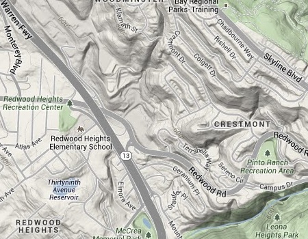
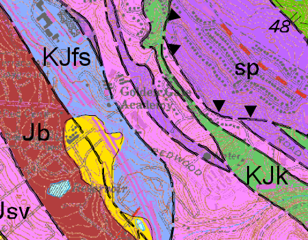
The Lincoln Square shopping center is a little neighborhood-scale set of shops on Redwood Road next to Route 13. It’s not very natural but it has some interesting natural features. Here’s the topography in Google Maps.
The graded area sits across the small valley of uppermost Lion Creek, running due south from top center. (A second branch of Lion Creek is to the west cutting through Holy Names University.) Its east edge is a cut into the hillside, exposing a bunch of serpentine rock. It’s the little strip of purple on the geologic map of the same area.
You can see the rock next to the parking lot . . .
. . . and in more detail behind the Safeway and the other building full of shops. This exposure is quite spectacular, but I was just doing a reconnaissance and didn’t linger.
I was actually visiting here to look for signs of the aboriginal hematite workings. This is where the local tribes came to dig Oakland ocher. This is as close as I got to that, a boulder rich in iron oxides along the north driveway entrance.
I have only the most preliminary ideas about this area. The map classifies this area as Franciscan sandstone, and this boulder doesn’t contradict that. There are other brief nods to the original landscape studding the parking lot, but on whole it’s pretty sorry-looking.
My idea is that in this part of the world the development of ocher requires serpentinite and a suitable host rock for the oxides to grow, and that the process happens underground at the base of the soil. It takes careful excavation by nature to reveal this fragile material without washing it away, and Lion Creek and the Hayward fault (on the left edge of the map) combined to do that here.


9 August 2014 at 1:40 pm
Hi Andrew,
Not sure if you’re checking these older posts. The Native Americans “harvested” the ocher further up the hill from where you took these photos. This entire hill is an enchanting place.
I wanted to let you know that I’m leading a tour of Sibley next Saturday, August 16, at 10 a.m. I’m using some of the information from your blog (especially a couple of your maps) and wanted to let you know that.
I’d love to take you up that hill behind Safeway to see the ocher deposit. It’s more substantial (and more impressive) than the one on the Holy Names campus. There’s also yellow ocher there. I’d like to get an expert to have a look at this hill before Safeway destroys it.
23 May 2018 at 7:50 pm
I live above the Lincoln Square shopping center and I remember when it was developed on the site of an old quarry in the ’60’s. My long-time neighbor, Dr. George Kido, now deceased, told me he fell in love with the geology of this part of the Oakland hills as a young boy. Later, he later chose to build his home along our Lion Creek tributary, because it appears to physically divide our ocher neighborhood from the Crestmont serpentine hillsides on the other side. Dr. Kido also told me he discovered our neighborhood when he was a kid and money was tight. He and a buddy took the streetcar from Alameda to look for pyrite crystals to operate their ham radios. This was in the years before WWII, perhaps about the time the Leona and Alta mines were closed.
By the way, here is a link with a bio for Dr. Kido, a most remarkable man who lived through a remarkable period of time: https://postoninterneeobituaries.blogspot.com/2011/06/george-seiji-kido-phd-1916-2010.html
[Very cool. I love stories like this. — Andrew]