During the eight years I was surveying every sidewalk in Oakland, taking in the geology and geography as I went, I took thousands of pictures. Here’s a baker’s dozen of my favorite shots from the fan-shaped body of ancient alluvium that dominates central Oakland, specifically the large segment I call lobe 4.

Every part of the Fan makes an interesting walk because of its rolling topography and the charm of the neighborhoods, different from block to block. If you get any message from this love note to lobe 4, I hope it’s an urge to take lots of walks there.
The lobes of the Fan are defined where streams have cut through it all the way across to bedrock. Whereas the four outermost lobes are simple landforms, the inner four have been sculpted within their borders as well as around them. And lobe 4, the biggest one, is full of variety at all scales. Here’s a closeup from the geologic map.

I think of lobe 4 as being divided, by two streams and a freeway, into four segments. (That would make them anthropo-geomorphic entities, I guess.) I’m giving them names for convenience, not to be confused with the names of the neighborhoods.
Lobe 4, like the other lobes, has an outer edge that’s rather steep, although the elevation change hardly reaches 100 feet. Here’s the north edge of the Glenview segment, seen from below in Indian Gulch.

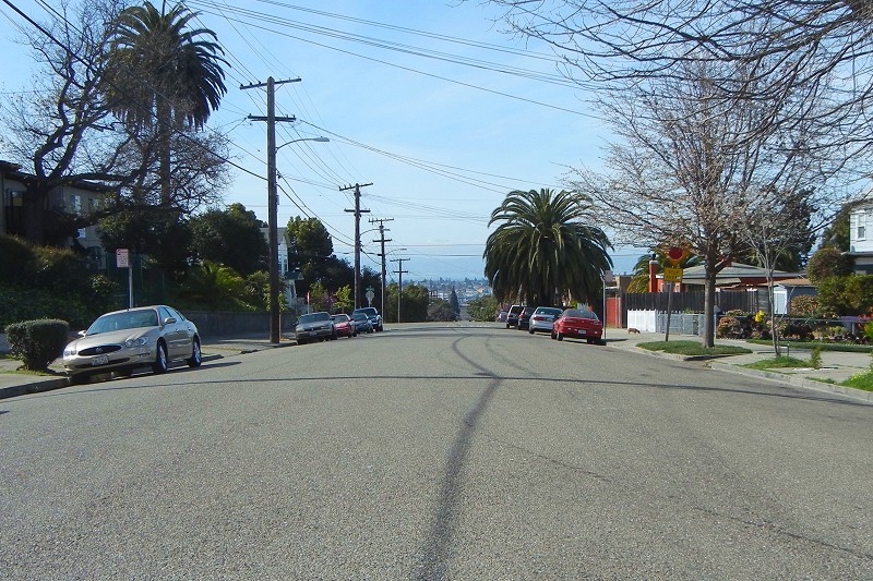
This is looking over the edge of the Haddon segment at Lakeside Park and Adams Point Hill, in lobe 3.

This is the view west across Alameda from the crest of the San Antonio segment, in San Antonio Park.

And this is looking over the valley of Sausal Creek from the east edge of the lobe.

The Haddon segment is separated from the Bella Vista segment by the valley of Park Boulevard Creek. This view from Ivy Hill looks across the valley to the Haddon segment’s highest point, occupied by St. Vartans Church.

From the top of Haddon Hill you can see over Oakland High and the freeway to the Glenview segment, where St. Mary Margaret Church sits. (The chapel in the foreground houses a pre-school today.) On the skyline is Sugarloaf Hill.

The Bella Vista segment is easy to spot from all over town, because of the allee of very tall palm trees on 9th Avenue leading to the former site of the “Borax” Smith estate. This is it as seen from the north on the Haddon segment.

And this is it from the other side, looking north across the valley of 14th Avenue Creek from the San Antonio segment.

The other major highlight of the Bella Vista segment is Highland Hospital, sitting at the top of the stream valley where it was sited to catch the healthful Bay breezes and let in the beneficial sunlight. Today’s hospitals have sealed windows and filtered air.

The weedy foreground is the scar of a landslide. The steepest parts of the Fan are prone to them.
From the high part of the Bella Vista segment, we can look east across the valley of 14th Avenue Creek to the San Antonio segment. The creek forks here, accounting for the bump in the road covered with fresh blacktop.

All three of the western segments are themselves dissected by small valleys, each segment with its own distinct pattern. On the San Antonio segment, among other features, is the gentle valley of 23rd Avenue Creek, occupied at its mouth by Garfield School and the colorful Church of Tonga. This is looking down the valley from its unobtrusive head.

Not all of lobe 4 is sloping. The Lynn and Tuxedo neighborhoods, on the Bella Vista and San Antonio segment respectively, are pretty flat. Tuxedo flat is strikingly flat, so level that I occasionally wonder if it’s a wave-cut terrace. But it’s probably just undissected.
The heart of the Glenview segment is rather flat, too. This is looking east on Excelsior Avenue toward the rise at the back side of the Altenheim, which overlooks the Dimond district in the valley of Sausal Creek.

To help you with all those locations, here’s a key to the 13 photos.

I hope this inspires you to get out on the Fan. Maybe I’ll see you there.

11 September 2017 at 3:54 pm
Love my hometown of Oakland.
20 September 2017 at 10:01 am
A wonderful photo essay!
6 June 2022 at 10:02 pm
I’m reading through your pieces on the Fan, some for the second time, after your post of 6Jun2022. This geography is compelling in so many ways – geological, historical, and for me personal. My first residence in California, in 1974, was on the Fan – (lobe 4) east of Park Blvd on Ivy Hill. And I think at the time, I recognized I was on a plateau that looked down on the lowlands below Foothill and looked up to the higher highlands above MacArthur. A few years later, I lived in Maxwell Park (lobe 6), in a (then) communal house at 3300 Kingsland Ave that was built by Frank Epperson, inventor of the Popsicle. For the past 21 years, I have lived on Sausal Creek alluvium just west of lobe 5 and the epicenter of the secular Spanish/Mexican East Bay at Peralta Hacienda. During Covid times I have done much more local hiking – and between that walking and your blog I feel like I have a much richer relationship with the Fan – and with what I have for myself called the East Oakland Plateau.
My sense is, from what you have written, is that the Fan is more of an uplift story than a deposition story – that it makes more sense to think of the main event as being a tectonic squeeze that has lifted up local sedimentary rock, and not so much as the deposition of some ancient river system bringing gravel down from high mountains to the east. Although it is (I guess?) a bit of both.