This hills-and-paths walk is number 20, “Broadway and Oak Glen Park,” in Charles Fleming’s Secret Stairs East Bay. This is not a bedrock walk, like the previous ones I’ve featured, but a landform walk. Let’s start this time with the topography.

This walk starts in the bayside flats, crosses two hills and two streams, and returns from the side of a third hill. The first hill is Pill Hill, and the second (Fairmount ridge is my name for it) and third are lobes of the Adams Point upland. These are parts of a larger structure that is central to Oakland’s character, an ancient Pleistocene alluvial fan. Here it is, marked “Qpaf” on the geologic map.

This walk takes in the leftmost edge of the fan, crossing two valleys of the Glen Echo Creek system which dissect the fan. The creek feeds the narrow west arm of Lake Merritt.
All right, here’s the route with the locations of the following photos.

Here’s the view up Hawthorne Avenue to the edge of Pill Hill. The land west of the fan is a modern alluvial flat with almost no topography to it beyond subtle levees along the modern Temescal Creek and the notorious filled-in marsh that once underlay the ill-fated Cypress Structure in West Oakland. The Pleistocene fan has fairly abrupt edges like this all around it.

As you go over Pill Hill and Summit Road on its spine, take a close look at the topography ahead of you. The near ridge is Fairmount ridge, made of Pleistocene alluvium, and the distant hills are Cretaceous and Tertiary sedimentary rocks. The eminence at the foot of the high hills is the older Franciscan block that underlies Piedmont and upper Rockridge.

The walk goes down into the valley of Glen Echo Creek. Brook Street is named for the Broadway branch of the creek, which is culverted under Mosswood Park and runs open to the sky in the backyards here. This shot is at the foot of 30th Street.
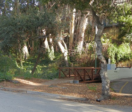
If you go upstream a little ways you can spot the culvert where the two branches join.

Next we climb the other side of the valley up a long flight of stairs, then turn right and follow the ridge top, along Fairmount Avenue, for a ways. A detour of stairways leads to Hamilton Place, at the toe of the ridge (the new Whole Foods place cut into that toe; unfortunately I never got a good look at the cut). From here we look across the next valley, which I might as well call Harrison valley.

This valley has a well-developed profile, but apparently it never had a permanent creek. The Oakland watershed map shows only a culvert here. Anyway, we walk up the far side of this valley and return west on classic Perkins Way, where we can look back at the other two ridges.

Back up on Fairmount ridge, we stroll up quiet Kempton Avenue, where this nice driveway wall of California mariposite lives.

Soon enough we find ourselves again at the steep edge of Glen Echo Creek valley. If you limit yourself to walking, Oakland is really quite a rugged place.

At the bottom is a precious remnant of early Oakland’s streambeds, Glen Oak Park. An old concrete bridge crosses the stream, and if you have time to stroll up and downstream there are some fine buildings here too.

I would be remiss not to mention that a little farther, at the foot of Piedmont Avenue, is a good sushi place, Drunken Fish.

29 December 2011 at 5:19 pm
I’ve been wanting to take this walk — seems like it might make a good addition to Oakland Urban Paths set. The only fault I found with Charles’ description is that he should have started and ended at the Commonwealth Cafe, since he tries to start or end on dining places. Nothing against Taste of Denmark nee Neldam’s, but Commonwealth is an English-style pub and fits better :-)
29 December 2011 at 7:11 pm
You could easily start on Piedmont Avenue somewhere, like Cato’s, then go through Mosswood Park and over to the west side of Pill Hill, or start at the Macarthur BART at Cafe Dejena.
30 December 2011 at 11:07 am
Used to spend hours in Glen Oak Park with the dog when I lived on Frisbie Street.
Haven’t been back there since ’98. I should wander over someday, such a nice little park to have around the corner.
31 December 2011 at 1:39 pm
I have to say, Jafafa, that your collection of transit tokens is wonderful.
31 December 2011 at 2:17 pm
The transit token collection is very cool! I’ve got a Key System token (solid) and a Railway Transit token (cutout around the ‘R’). I should photograph them and do a Key System post for Our Oakland.
7 January 2012 at 6:44 pm
By the way, that little roof on Perkins Alley: a historic horse car stop, later cable car stop that is miraculously still intact. It has functioned as an AC transit stop for years. The cable car barn was where Whole Foods now stands. Various Oakland Heritage Alliance tours cover some of this territory during summer season.
10 January 2012 at 12:57 pm
This brings back memories, as I used to live on Kempton. When I saw the steps, it’s like I was 8 again! Maybe one day I’ll return to renovate an old Victorian…
14 January 2012 at 7:18 pm
Thanks!
I have TONS of more transit tokens including some very rare bay area ones, but have been too lazy to post them as of yet.
14 May 2012 at 2:19 am
I did a version of this walk recently based on a specific premise. I found the first survey map of Oakland, from 1857, showing Glen Echo Valley and, notably, the presence of riparian trees along the valley and up the hill. I spent some time in the 28th Street cul-de-sac at the bottom of the path that leads to Hamilton St. If you go through the parking lots of the Christian Terrace buildings, to the south, there’s the hill descending on the left, with the middle school yard above. There’s oaks along that stretch, as well as pines of course. More interesting is that the parking lot narrows and at the end is a fence with a tiny part of Glen Echo creek daylighted below. And just to the left is another sloping part of the hill just brim-filled with oaks, extending behind the Kelley Paper building below and the school above. It’s just amazing what a beautiful little spot it is. There’s a locked gate on the other side, were the 1st Congregational Church parking lot…and more oaks, sits atop the very end of the hill, where formerly Lake Merritt marshes stretched away to the west arm of the lake.
14 May 2012 at 10:04 am
Cool! I’ll have to give it a look some time.