In my last post I talked about the Hayward fault itself, the actual crack in the ground. I argued that the extra hazard of living right on the fault doesn’t add much to the risk, which is already high for other reasons. Those reasons are mainly two: the size of likely earthquakes and the type of ground that they shake. This post goes into the ground and how the ground can fail during earthquakes.
The ground is a BIG factor in how the same quake affects different places, as we learned from the 1989 Loma Prieta earthquake. Vibrations from an event way down below San Jose damaged a number of buildings in downtown Oakland, some fatally, but none of them collapsed outright. By contrast, the same earthquake, at the same distance, singled out one type of ground — landfill in West Oakland, formerly wetlands of Bay mud — and brought down the Cypress Street Viaduct, crushing 42 people to death. Soft ground slows down seismic waves, which pushes their energy into a smaller space, and lowers their frequency. In a word, soft ground amplifies shaking.
The Oakland flats consist of alluvium and have no solid rock anywhere near the surface. They’re deep dishes of mud, sand and clay, saturated with groundwater. When you shake this kind of material, the water in it starts disrupting the sediment into a slurry. Think of the times you’ve played near the water at a sandy beach, patting the damp sand until it turns wet, shiny and loose. The water transmits the energy of your hand very efficiently and drives apart the sand particles.
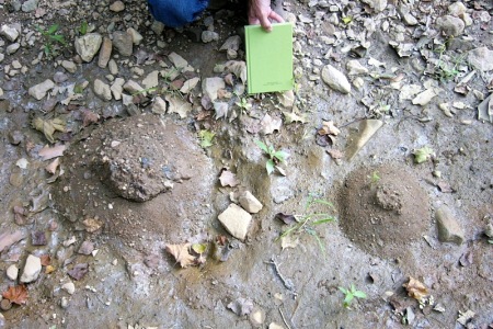
A moderate quake in alluvial ground will start triggering little eruptions of sandy water — sand boils.

Sand boils formed by the 2011 Virginia earthquake; photo by Mark Carter, US Geological Survey
Larger quakes raise the risk that the ground will fail en masse, losing its strength in the phenomenon called liquefaction. If this happens near a vertical boundary, like a streambank or a harbor channel, the ground may spread out sideways (lateral spread). Not just buildings but anything on or in the ground, like pipelines and railroad beds, can fail during liquefaction.
To help guide building designers and city planners, maps showing liquefaction-prone areas are published by the US Geological Survey and by the California Geological Survey. Here’s a sample of the state’s map, which shows the suspect areas in green. These are not areas of guaranteed damage, but zones where we should be aware of the likelihood of damage.
Notice that flat, wet areas aren’t limited to the coast — green areas extend up every stream valley, even in Montclair.
The high ground has its own geologic vulnerabilities. First, of course, is that it’s already prone to landslides: the slopes are steep, our rocks are generally soft and like to disintegrate into soil, and their bedding is steeply tilted, which helps rainfall to infiltrate them. The map above shows landslide-prone areas in blue, in the upper right corner east of the Hayward fault (the black line). Strong shaking will trigger landslides in these areas — not everywhere, but anywhere.
Notice that there’s blue immediately west of the fault too, in Piedmont and west Montclair. The blue areas are smaller there because the rocks are different: harder Franciscan rocks as opposed to softer Great Valley Sequence rocks.
The second geological factor that affects how this ground responds to earthquakes is its topography. Steep ridges tend to direct earthquake waves upward in a sort of whip-crack effect, so that the highest ridgetops shake most violently. This is an area of active research, because it’s complicated.
Finally there’s the middle ground, the low hills that sweep from Pill Hill through Grand Lake and Haddon Hill and Maxwell Park to Evergreen Cemetery. These hills have no bedrock, but they’re made of alluvium that’s older and firmer than the flats. The problems lie around their edges, where the slopes are steepest and prone to landslides, like those at Jungle Hill and McKillop Road and Wallace Street, among others.
If you live in parts of Oakland that consist of these types of ground, I won’t say “you are warned,” because I’m not licensed to practice geology, but you are hereby informed. These facts are part of what makes up your overall picture.
My next post will get into earthquakes themselves, and how they’ll affect Oakland.

14 September 2020 at 3:40 pm
Your article made me think of the presentation at NCGS about the massive computer modelling done on the Hayward Fault that surprisingly, showed much higher ground motions east of the fault than west! Castro Valley, Lamorinda, Livermore Valley, even Walnut Creek and Concord if my memory serves me…ouch. I think that it had to do with a ridge of harder rock just west of the fault from East Oakland to San Leandro and beyond reflecting the waves. The spoke of how, had San Leandro had any municipal presence at the time of the last great earthquake on the Hayward Fault it would have been called the San Leandro Earthquake and Fault.