
Leona Canyon Regional Open Space Reserve is an East Bay Regional Parks District property of some 290 acres that is entirely within the Oakland city boundary. It’s got rocks.
The canyon was cut by Rifle Range Branch, part of the Arroyo Viejo stream network. The branch joins Arroyo Viejo underneath I-580 at the turnoff to the zoo. The topography is rugged. I surmise that the rifle range that gave its name to the creek was here once upon a time, because it’s the sort of place where you could shoot a lot without disturbing the rest of the city.

Here’s the geology of the same piece of ground.

The pink “Jsv” is the same metavolcanic rock (Leona “rhyolite”) found in the Leona Quarry just to the west. The green units are the familiar sedimentary rocks of the Great Valley Sequence, tilted upward so that they get younger to the east. The units, in order of age, are the Knoxville Formation (KJk), the Joaquin Miller Formation (Kjm), the Oakland Conglomerate (Ko) and the Shephard Creek Formation (Ksc). You can see that the canyon is controlled by the faulted contact between pink and green.
OK! The creek is dammed at the base of the canyon, presumably just for flood or sediment control. Maybe the rifle range used to be here. Anyway, the creek is fairly level throughout the park, creating a nice bit of habitat.

As you walk up the creek, it wanders along the contact between the two major rock units, so you’ll see a mixture of boulders in the creek bed. The Knoxville is a shale with some sandstone, not very distinguished, but near its base it includes some conglomerate and breccia: rocks made of pebbles and cobbles derived from the Leona keratophyre. This example is from the high end of the trail, in the upper left corner of the geologic map.

The reserve has two paths that lead up the canyon’s sides. The Pyrite Trail goes west through the metavolcanics. It’s shady and steep. I should note that I saw no signs of pyrite on it.

Along this trail you’ll see the Leona metavolcanics, kinda ragged-looking stuff that’s been chewed up and spit out a few times since it was a volcanic island arc during the Late Jurassic.

There are nice views of the other side of the canyon, which is more open and chaparral-y.
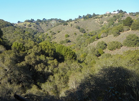
The trail up that side is called the Artemisia Trail. I’m not sure that either trail’s name means much. It passes a lot of this fine-grained sandstone.

Higher up, you get a good look at Sugarloaf Hill, which is a prominent part of the hills’ skyline as seen from the north. This view is from the south.

There seem to be a few informal trails on it, and the view must be fantastic. But the Artemisia Trail offers superb views across the middle and south bay, too. I’ll be back.

23 April 2013 at 5:56 pm
That “big knob” is easily accessible from the upper end of the Leona Canyon trail, at the back of Merritt College.
23 April 2013 at 7:48 pm
I would have climbed it, but I’d already taken both side trails and was wiped out.
2 May 2013 at 4:40 pm
Andrew, do you know what that big knob is and how it got there (and why its’ there)?
4 May 2013 at 10:02 am
Dennis, you’ll see on the geologic map that a fault is inferred all the way around that block. Perhaps it was a small seamount or volcanic pile of some sort that remained relatively intact. The faults are what favored the erosion that carved these hills. I can’t say more since the map shows no stratigraphic information.
8 August 2013 at 2:50 am
Leona Canyon has some fascinating historical features as well. The trails were all navigable roads; you could drive from the Sulphur Mine down to where the bottom of Keller is. Artemisia let you drive to Skyline and the Pyrite? All I know is that there was a structure near the top that was supplied with electricity (look for the hidden statue of a dog). There’s actually an old fashioned stone lined well in a soggy spot where the trails all intersect, also hidden. Nearby, above the trail, are the remains of a stone chimney that belonged to a tiny log cabin. Now, if that’s not enough for you, there is a very hard to reach place that had house, now burned to the ground. There is a rather large garbage dump, and a large metal roofed structure that was possibly a stable. There was a road to it off the main trail and you will see it on some maps, but it’s completely disappeared in the undergrowth. You cannot see this site from any vantage but from above, and even then, it’s hard to spot. I won’t say exactly where it is, You can find it on Google Maps or Google Earth
30 June 2023 at 1:45 pm
Rifle range: https://www.ebparks.org/sites/default/files/Final%20Leona%20Heights%20Fact%20Sheet%20January%202022_Rev1%20%28002%29.pdf