Archive for the ‘Oakland gabbro’ Category

Oakland and the Coast Range ophiolite

24 June 2019

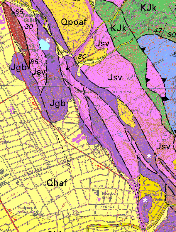
A commenter asked, in connection with a recent post, if I’d written anything about Oakland’s ophiolite. The answer is, not specifically until now. The Coast Range ophiolite (OH-feel-ite) is a string of mostly disconnected outcrops of unusual rocks that extends north almost to Redding and south almost to Point Conception, rather like the way my writing about it runs through the ragged string of posts on this blog between late 2007 and today. In Oakland, the serpentinite patch is part of it, the San Leandro gabbro is part of it, and the Leona volcanics are part of it (see posts about that part here and here).

Here’s a recent simplified geologic map from a 2005 paper by ophiolite savant John Shervais (doi: 10.1130/B25443.1, available here) showing the most important bits of the ophiolite in black. It’s kind of a privilege to have a piece of it in our city.

The details in California are intricate and I’m about ankle-deep into them at the moment, so I’ll be pretty general here. Ophiolites were first recognized as a suite of related rock types over 200 years ago, at the dawn of scientific geology, in the Alps. Alexandre Brongniart gave them the name, which means “snake rock” in scientific Greek, because serpentinite (“snake rock” in scientific Latin) is so typical of them. About 50 years ago, at the dawn of plate tectonics, they were recognized as pieces of oceanic crust that somehow have ended up on land during the elephantine dance of the tectonic plates.

The oceanic crust of most ophiolites is not as well organized as the standard oceanic crust formed at mid-ocean ridges. It forms in the roiling setting near subduction zones, where subducting plates sink straight down and draw the other side toward them. (This situation, called slab rollback, is the opposite of what we’re taught in popular accounts that talk about subduction in terms of colliding continents and mountain-building.) As the plate on the other side is stretched thin, new magma forms beneath it, rises and freezes into fresh oceanic-style crust (the ophiolite). It’s because most ophiolites form near land next to subduction zones (the “suprasubduction-zone setting” in academic lingo), not way out to sea at mid-ocean ridges, that we find scraps of them plastered onto the continents in a couple hundred places around the world. There are some other tectonic schemes that make ophiolites, but this is the typical one.

Ophiolites consist of rocks that correspond to the major layers of oceanic plates, which are a deep base of peridotite, a middle layer of gabbro, an upper layer of basalt and a cap of mixed seafloor stuff: red clay, seamounts, volcanic chains and the odd limestone basin here and there. And most of these can be found in Oakland. The peridotite, when seawater reacts with it, turns quickly into serpentinite (but you can see rare remnants in places).

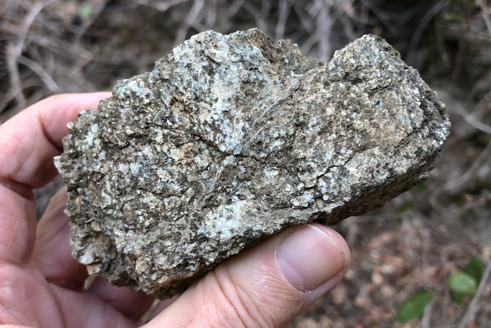
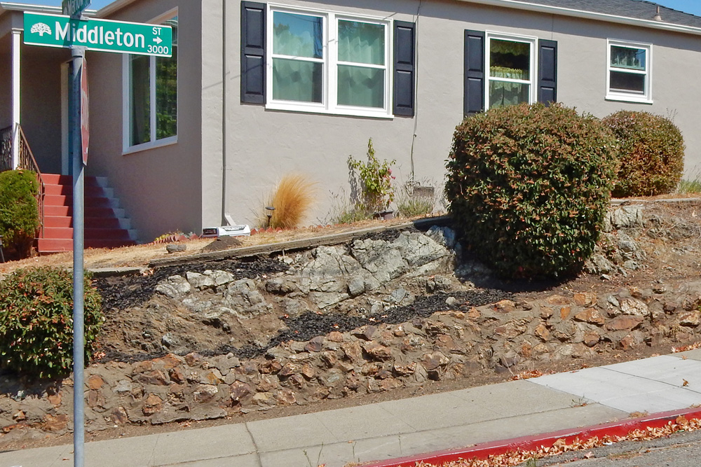
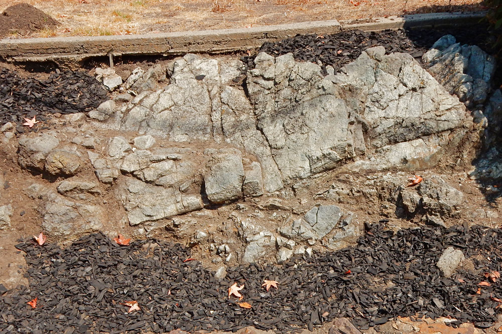
The gabbro, a coarse-grained rock of the same composition as basalt lava that has cooled slowly enough for visible mineral crystals to grow, underlies much of San Leandro and the deep-East Oakland hills.

And the Leona volcanics is a big pile of volcanic ash, shot through with dikes of basalt and now strongly altered, that sat on top.

The Coast Range ophiolite is highly disrupted now. It’s been caught up in millions of years of squeezing, stretching and kneading North America’s western edge — and that was before the San Andreas fault system arose and smeared everything sideways.

A handful of intrepid specialists continue the work that Brongniart started, reassembling and correlating and extrapolating and collecting ever more data. Ophiolites are important in the bigger scheme because some of them are the only pieces of seafloor rock that are older than the present ocean floor (which barely covers the Cretaceous period, back to about 140 million years). But if ophiolites are born poorly organized, unlike proper deep seafloor, attempting a perfect restoration may be an delusion, a will-o’-the-wisp. Our insights may always be a string of fragments, and we may have to let mystery be, but we have to try.

I also wrote this introductory piece about ophiolites for another website, once upon a time.

South Dunsmuir Ridge

29 May 2017

I finally got to a sweet corner of town last week, the sunny side of Dunsmuir Ridge, this lovely hill in the Google Maps 3D view.

The view is to the north-northwest, such that the Hayward fault runs straight up about a thumb’s width from the left edge. The maps below start with the 1915 topo map, in which the ridge’s top is the lobed outline of the 625-foot contour.

That straight creek valley along the hill’s south side — the gorge in the foreground of the top image — keeps catching my eye, but it seems to be inaccessible, which might make it Oakland’s wildest piece of land. The watershed map below may help in visualizing the hill and its surroundings. The two black dots are where the fire trail I took starts and ends.

Dunsmuir Ridge is city land, rescued from development after several aborted attempts to put high-end estates on this broad hilltop overlooking (in both senses) the deadly Hayward fault. The fire trail starts at the end of Cranford Way and winds up the ridge to join the fire road from the other side, which I’ve featured here before.

The walk is very scenic. To the north, downtown rises against Mount Tam.

Or if you prefer, there’s the new profile of San Francisco.

Higher up, the view opens out. Here San Leandro Creek is made visible as a line of trees coming out of the canyon toward its mouth near the airport.

But the main attraction is to the south. This is the best place to take portraits of Fairmont Ridge and its quarry scar. Unlike most places, this trail sets off the hill with a foreground of wild, forested land.

The prominent cleared space midway up the trail — a staging pad for firefighters — has regular visitors who find the spot special.

Interestingly, this spot is mapped as a patch of the peculiar Irvington-aged gravel that first brought me to Dunsmuir Ridge in 2009. However, I didn’t notice much of it, if any. See it on the geologic map — the white dots mark the ends of the fire trail.

There are rocks to be seen too. The soil is thin in most places. This little cut displays a profile of the soil and the decaying bedrock — saprolite — just beneath it.

The bedrock varies, and it doesn’t match the geologic map very closely. I would say nearly all of the lower part is not Leona volcanics (Jsv) but San Leandro Gabbro (gb). It has the gabbro’s pepper-and-salt appearance but is stained orange instead of the pristine rock’s bluish gray (as I saw earlier that day in San Leandro). You’ll see it well exposed in the trail itself, where this winter’s heavy rains carved fresh runnels.

If the city fills them before you get there (which it should before they become gullies), there are still roadside exposures that display the rock well, and it’s unmistakably gabbro where the map says volcanics. The top of the hill, though, is unquestionably Leona volcanics.

My long-term plan is to revisit every bit of bedrock in Oakland and log it. Besides sheer nerdery and the chance to improve the map, my motive is to come back to views like this one over and over again.

The old quarry is still for sale. Developers have tried to put houses there, but they keep getting shot down. Better, I say, for the Regional Parks District to acquire the land and develop it for quiet recreation.

Three bits of gabbro

20 February 2017

I’ve noted that while the San Leandro Gabbro has a presence in easternmost Oakland, it’s hard to find. The geologic map shows what seems like a lot of it, marked “Jgb” for Jurassic gabbro.

But if you poke around on the ground, nearly all of those sites are inaccessible due to steep woods, roads or housing tracts. But I’ve found some. The three spots are marked on the map with white asterisks. The northern one is at Seneca Reservoir, right next to the Hayward fault, the middle one is in the woods along the route of Ramble 3, and the southern one is in Sheffield Village at the north end of Middleton Street where it meets Marlow Drive.

The northern site, Seneca Reservoir, was once the upper pit of the old Catucci quarry. (The lower pit was repurposed as the site of Bishop O’Dowd High School.) Not much of it is accessible, but here and there you can spot pieces of the quarry waste. It looks like nothing else in town and everything like San Leandro’s namesake stone.

The middle site lies along the trail and is kind of unexpected, but the rock is definitely the same stuff.

This too is an out-of-the-way place. You’d have better luck farther south at Oakland’s utter end in the Dunsmuir Hills.

The Middleton Street exposure, at least, is real easy to visit. Oddly, the first time I came through here, in 2013, I paid it no mind, focusing instead on the other side of the street.

This site too is very near a strand of the Hayward fault, so it’s been rattled and squeezed for quite some time. It has a battered appearance, even a little fried.

And no matter how close you get, it doesn’t show much detail. As a whole, though, it has the typical color of the gabbro: light gray with a slight blue-green tinge. This resulted from petrochemical disruption at the time of its eruption, some 165 million years ago, when a pulse of younger magma sent up fluids that changed its black pyroxene minerals into green amphibole and some other greenish minerals — an obscure process known as uralitization.

I mentioned the Hayward fault being next to the reservoir. We probably would think twice before building a hilltop reservoir there today.