Archive for the ‘Oakland rock types’ Category

Vicente Canyon

16 October 2023

Claremont Canyon and Temescal Canyon are big excavations into the rising Oakland Hills, and each is a traffic corridor. Between them is a smaller valley — a gulch, really — that I think is pretty distinctive, enough so to merit the title of canyon. I name it Vicente Canyon, after the stream running down it, Vicente Creek. All three canyons feed their runoff to Temescal Creek, as shown here in the county’s watershed map.

Take a close look at it (click it to see full size). The land surface is shown as a digital elevation model, and without all the distracting street names and such, some things are obvious. All three canyons are defined by the Hayward fault, which runs from top center to lower right. The hills on the east side are being pushed up, and the ridgetop is around 1300-1400 feet elevation. Vicente Canyon has only a slightly smaller elevation range, but it’s much shorter; that is, its slope is steeper. The two bigger canyons are long. Their streams, Claremont Creek and Temescal Creek, have stretches that are almost level, but not Vicente Creek. It’s working harder than its neighbors.

Here’s a thing people may not get about streams: they only erode and cut down their own narrow streambeds. Other than that, all they do is carry away what falls into them. As the Oakland Hills rise, the streams that drain them are compelled to keep cutting straight down to the level of the land at the fault, which is the local base level. This is a very effective process, geologically almost instantaneous — for example, you’ll notice that wherever tributaries join a larger stream, they always meet at the same level. The big stream is the base level for the little one.

Vicente Canyon has extra-steep walls that are ready to slide, and as I’ve explored this valley in recent weeks I’ve seen a lot of landsliding. Here’s a little example from high up in the catchment, on the unbuilt extension of Kenilworth Road.


A scoop of hillside has slumped and rotated on a curving underground surface. The tree died when its roots were torn off.

Down by the creek itself, the slopes are even steeper. This bit of Westview Drive suffered a fresh debris slide (what’s typically called a mudslide) just last winter, next to an older one.

The state’s official geologic hazard map corroborates me. Here’s the area that includes Vicente Canyon. The blue tint signifies areas at high risk of landslides.

The diagonal strip is the official “earthquake fault zone” defined by the state and the black line inside it is the trace of the Hayward fault. With that in mind, look at the digital elevation model of the same area.

See how the stream bends as it approaches the fault? It’s a great illustration of what the fault does to the landscape. The bottom side is moving leftward an average of about 10 millimeters a year. (The uplift part I referred to earlier is more like 1 mm/yr.) Humans can’t perceive movement that slow, but streams feel it as surely as we feel an escalator.

The rocks in Vicente Canyon are almost entirely mudstone of the same vintage as the rocks of Shepherd Canyon.

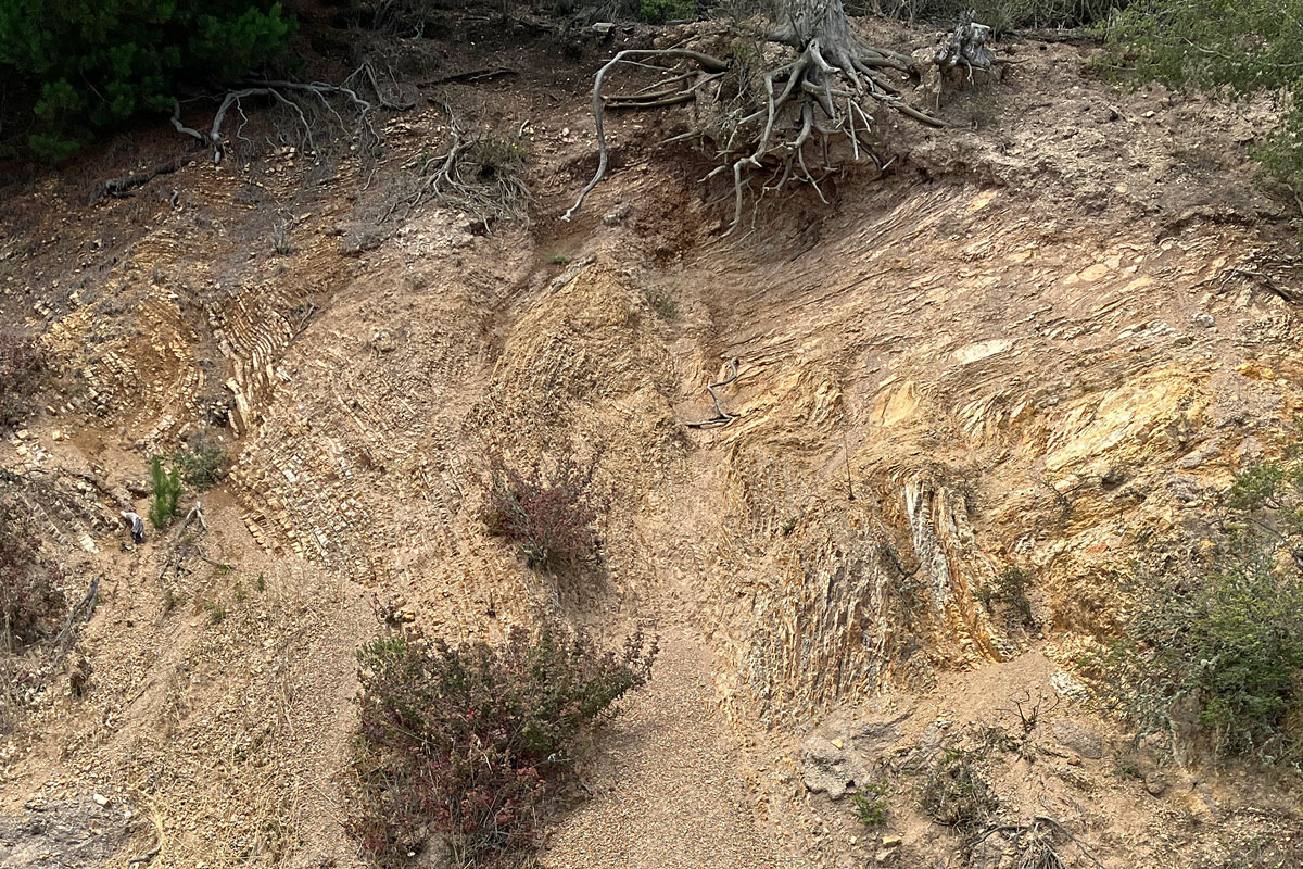
They’re rarely seen, though. They quickly turn back into the clayey sand they started from, as exposed in this excavation on Westview Place.

Once the creek crosses the fault, everything changes. The rock there is Franciscan sandstone, somewhat harder. The stream becomes a rocky gorge that winds through wooded yards for a few hundred meters to its junction with Temescal Creek, which is now culverted. The neighborhood is different, but not without its own charm.

All of Oakland’s high hill neighborhoods stack elaborate houses along narrow roads on steep, not-too-stable slopes, but because of its underlying configuration, the Vicente Canyon neighborhood is even more like that. At its best it presents a picture of architectural and engineering heroics in a lovely woodsy frame.

And especially along the canyon’s upper walls, the views across the fault to the San Francisco Bay basin are luxurious.

But the Vicente Canyon Hillside Open Space, a couple acres of oak woods between Vicente Road and Gravatt Drive, is a fine place for spry visitors. The locals manage a foundation that tends the land as a fire barrier.

Its benches have million-dollar views and none of the hassles of living up there.

The Skyline chert exposure

1 August 2022

For several miles starting near the top of Marlborough Terrace, Skyline Boulevard runs through a belt of blond chert that makes for striking roadsides and some of Oakland’s highest homes and best views. Near the south end of this stretch, north of Elverton Drive, the road runs east-west for about 700 feet. It’s just you, the view, and these rocks. In my book I describe them as “pale, flinty chert in layers a few inches thick alternating with thinner layers of soft brown shale. The layers, thousands of them, stand on end like a storm-swept forest of golden bamboo.”

Note that the nice wide verge is now blocked by a line of huge logs. These extend for miles along Skyline and Grizzly Peak Boulevard. There are still small places to park, though.

Here’s the location on the map. The land is an outlier of the Sibley Volcanic Regional Preserve, and a little trail runs along the ridgetop between the two boulevards.

The rock in this roadcut is chert: a hard, waxy-looking stone made from accumulations of microscopic diatom skeletons. It ranges from white to brown to black, simple to complex. It dates from the middle of the Miocene epoch, probably the Tortonian age around 12 million years ago.

The complexity extends to the larger, outcrop scale. Notice how the straight, even bedding on the left gives way to distorted layers on the right. The boundary between them is a fault. There are several more along the roadcut.

In addition to the faulting, this even-bedded, slowly accumulating sediment was periodically disrupted while it was still soft, presumbly by large undersea landslides triggered by earthquakes, just like today. Here’s a more extreme example; notice the wisp of chert entrained in the mixture on the left.

Here’s a foot-thick bed of clean white sandstone, preserving an ancient submarine landslide. By the way, it appears that nearly all of these rocks are overturned, their upper surfaces now facing to the right.

In the middle part of the roadcut, it really gets hairy. (This is the biggest image of the set.)

Other parts of the roadcut look tidy and regular, but erosion has cut into softer parts of the formation in the century since Skyline was built to attract developers.

Here’s a closeup of the groove in the middle. What caught my eye was the dark zone in it with orange veins, which shed pieces onto the roadside slope below.

The material (on the right) is a lightweight siltstone shot with films of black.

It’s likely that the black films are the remains of crude oil — not the only possible explanation, but it’s how to bet. Chert is a source rock for petroleum because the diatoms that compose the rock manufacture oil to help their opal shells float. As the diatom ooze becomes rock, the oil is released and migrates elsewhere until it’s trapped in an underground structure, eaten by microbes or oxidized in the atmosphere. Our Miocene chert is a close relative of the widespread Monterey Shale, which is responsible for California’s richest oil deposits. So the zone of orange veins might be a former escape avenue for the local oil — an injectite.

But above the roadcut, a little off the ridgetop trail, I encountered an intriguing alternative in this heavily etched material impregnated with silica.

Here’s a side view of another specimen showing the veins of hydrothermal quartz (chalcedony). The matrix between them appears to be the same stuff of the orange veins.

Now the formation of chert from plain diatom ooze, or diatomite, takes place at low temperatures and pressures. It’s very gentle. Hydrothermal silica is a sign of higher temperatures. Something more active than trickling crude produced this. Again, various explanations are possible, and these scattered blocks of rocks aren’t firmly connected to the putative injectite in the roadcut. I’ll just have to poke around here some more. The complexities multiply.

By the way, maybe some of you remember when this stretch of road was a cool, shady run through a high eucalyptus forest. That was how it was when I first explored the area. Google Earth stacks imagery of this area going back to aerial photos from 1939, and there was no eucalyptus here at all until the 1980s. Yet the trees were a hundred feet high in late 2003.

The Park District took them out around 2005, and in the fall of 2009 just a little fringe along Grizzly Peak was left.

Twelve years later, chaparral and oak-bay-madrone woods had made quite some headway.

But if you ask me, the site would be an excellent one to try restoring the traditional fire-groomed grassland that once covered all the hills north of the redwood groves. The Park District owns it, and California still has experts in the old ways.

Avalon Hill

18 July 2022

There’s a little hill south of the UC Berkeley campus, near the Claremont Resort and the Hayward fault, that cried out for a visit. It stands out on Google Maps (with the “terrain” setting, naturally).

On the geologic map, it appears as a blob of Franciscan sandstone.

I thought I’d give it the same treatment I gave Easter Hill in Richmond: explore the rock and comb through old maps and documents.

The road running by the south side of the hill is Avalon Avenue, so I’ll call it Avalon Hill. It was never exactly a landmark, but it has a past and retains a certain presence.

The hill was owned by John Kelsey in the late 1870s, and Kelsey Street commemorates his name. Today’s Claremont Avenue was called Telegraph Avenue at the time, as shown in the 1878 Thompson map.

In 1884 the Berkeley Water Works excavated a large reservoir on the hill, and the following year the Alameda Water Company took it over. The Garber Reservoir held a million gallons and was lined with concrete. Here it is on the 1894 Wagner map.

It is not to be confused with today’s Garber Reservoir, the flat-roofed structure 1500 feet south on the north side of Claremont Avenue.

Development began to surround the hill in the 1890s and 1900s, especially after the 1906 earthquake. From then until the 1930s, the struggling private water companies of the northern East Bay merged, the East Bay Municipal Utility District swallowed them whole, and the water delivery system began a slow and expensive transition to the rational and robust setup we enjoy today. The 1912 street map shows the property still in the hands of the Peoples Water Company, the next-to-last of the private firms.

I don’t know when the reservoir was decommissioned and removed, but the homes adjoining it were built starting in the 1910s. The large home on the hilltop was apparently built in 1960.

The best picture of the hill itself is the digital elevation model made from a special survey of the Hayward fault. Its sides are too steep for streets, which has helped keep it quiet and isolated.

On the north side, Garber Street has a rustic interlude where a narrow road sashays down the hillside like a mini-Lombard Street. Avalon Avenue, on the south side, is blessed with three stairways, one at the end and two going down to Russell Street.

All those old houses with their mature landscaping cover up the rocks very effectively, I can testify. But there’s an excellent exposure at the end of Avalon Avenue underneath a private driveway.

What few flat surfaces there are on it appear to reflect fracture planes, imposed by the tectonic stresses on the rocks over the years, rather than any original bedding.

Up close, the rock is a hard siltstone much like the rocks in the quarries of the Piedmont crustal block: the Bilger, Blair and Davie tennis stadium quarries.

But just looking at it isn’t definitive. The geologists who’ve mapped it have left it unclassified (KJfs) rather than lumping it with the sandstone of the Novato Quarry Terrane (Kfn) exposed in the Piedmont block to its south. Here’s a larger piece of the geologic map showing what I mean: it might be the northern tip of the block or it might be the first of a string of rock bodies to its north. The thrust fault leading up to it, the dotted line with the teeth on the upthrown side, is reasonable but conjectural.

Avalon Hill is a cool little bit of Berkeley. Stick your nose in and poke around some time.

Yes, “Avalon Hill” is a private joke. My siblings and I warped our personalities in the 1960s by moving armies and fighting over the rules of the board-based wargames produced by the Avalon Hill company, starting with Tactics II and Gettysburg.