Archive for the ‘Oakland blueschist’ Category

Knowland Park knockers II: Rocks other than chert

2 November 2015

The distinctive landscape of Knowland Park owes much to its large exposure of Franciscan melange, in which lumps of various rock types stick out of the ground like raisins in pudding (or whatever culinary simile you prefer). A few weeks back I featured the chert knockers, because there are so many, and this week’s subject is the ones that aren’t chert.

Here’s the geologic map showing the Franciscan area, labeled KJfm (for “Cretaceous/Jurassic Franciscan melange”). The places featured in this post are numbered 1 through 8 from north to south.

knowlandKJfm-knockermap

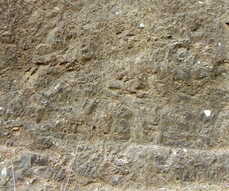
Knocker 1 isn’t really a knocker, but an exposure in the fire road, of greenish serpentinite.

Knowl-JKfm-knocker1

I include it because there are relatively few in this piece of melange. Other melange areas, like those in San Francisco or Marin County, may be mostly serpentinite, but not here.

Knocker 2 is at the edge of a cul-de-sac overlooking the gorge of Arroyo Viejo. It’s a lovely greenstone.

Knowl-JKfm-knocker2

A closeup shows the greenish rock, which is a metamorphosed lava, along with its iron-rich weathering rind and the carbonate veins that are evidence of its deep-sea origin (more here).

Knowl-JKfm-knocker3

Knocker 3 is exposed along the road just above here, a nice graywacke, or dirty sandstone.

Knowl-JKfm-knocker4

The Piedmont block, Oakland’s other body of Franciscan melange, is largely graywacke.

Knocker 4 is the big one, which caught my eye the first time I set foot in the park.

Knowl-JKfm-knocker5

Its bluish color stands up to close inspection. This is a classic high-grade block, a body of rock that was carried deep into the Earth and returned to the surface quickly enough that the high-pressure blueschist minerals it turned into were preserved.

Knowl-JKfm-knocker6

You have to look closely at these rocks to see past the lichens that tend to cover every exposed surface. Geologists carry hammers to ensure fresh exposures, but rocks in the park should not be hammered.

Knocker 5 is just up the hill. I haven’t given it a good look yet, but my initial impression is that it’s lava.

Knowl-JKfm-knocker7

Knocker 6, across a small gully from knocker 4, is populated by a clump of trees. I think there’s a reason for that because the rock fractures nicely enough for the roots to reach deep.

Knowl-JKfm-knocker8

I interpret it as metamorphosed lava, from its greenish color, extremely fine grained (aphanitic) character and massive fabric.

Knowl-JKfm-knocker9

The next two knockers are outside the park — the Franciscan doesn’t honor property lines, and the Chabot Park neighborhood once looked just like Knowland Park.

Knocker 7 is on posted land at the end of the public part of Kerrigan Drive. I think it’s serpentinite . . .

Knowl-JKfm-knocker10

. . . because that’s what’s underfoot here.

Knowl-JKfm-knocker11

Knocker 8 is exposed along lower Lochard Drive and is too large to photograph easily. Looming over the road, it looks like basalt lava.

Knowl-JKfm-knocker12

But a fresh exposure shows some cryptic internal features, plus extensive deposition of iron oxides from weathering below ground.

Knowl-JKfm-knocker13

I’ve visited this site twice and am still not sure what to call it.

There are more knockers to be found in Knowland Park and south of the park. I plan to keep up my search to the south end of the Franciscan, along Chabot Reservoir.

Once again, I hope you’ll take part in the blog survey between now and November 20. It has prizes.

On Oakland’s blueschist

22 June 2015

It may seem like I have a fixation on blueschist. I’ll admit that. I have a fixation on every rock type. Here’s a fine blueschist boulder at the very north end of Castle Drive, in the Piedmont Pines neighborhood.

higradeblock-mountaingateway

This qualifies as a knocker, and it also qualifies as a high-grade block. “Knocker” is local geologists’ slang for a small block of resistant rock that protrudes out of an area of melange (like those in Mountain View Cemetery that I feature here in the “cemetery knockers” category). By default that’s understood to mean Franciscan melange, because melange—a collection of geological bric-a-brac mixed in a matrix of shale—practically defines the Franciscan complex. However this high-grade block is in the serpentinite patch, part of the Coast Range ophiolite, which also qualifies as melange.

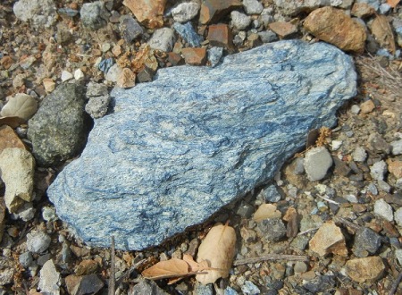
Oakland’s serpentine patch contains a goodly share of blueschist. This is a piece of it near Redwood Road that was lying right next to a piece of classic serpentinite.

blueschist-redwoodrd

The key indicator for me is the color, which is typical of the mineral glaucophane. Glaucophane is described as various shades of blue, while serpentine is described as varous shades of green. They differ in their luster and hardness as well. My gold standard is the classic occurrence at Ward Creek near Cazadero, which I visited in 2005. Here are two photos from there.

wardcreek1

So glaucophane tends to a dusky, blue-jean blue or gray-blue. Green minerals like chlorite, epidote and omphacite may accompany it as they do here.

wardcreek2

Technically, blueschist is a metamorphic facies rather than a specific rock type—it’s a set of typical minerals that form at a specific combination of heat and pressure. Glaucophane and lawsonite indicate the blueschist facies in metamorphosed rocks of mafic (MAY-fic) composition, like basalt. In metasedimentary rocks, the indicator minerals are phengite, chlorite and quartz. Those won’t make a blue rock (they’ll be greenish). So amateurs like you and me shouldn’t read “blueschist” and envision something blue. But in Oakland, we do have real blue blueschist. (Some of the Franciscan sandstone also has blueschist-level minerals in it.)

Serpentinite doesn’t change much with pressure. It’s a cryptic rock that doesn’t retain many traces of its history. But the blueschist that accompanies it in the Oakland serpentine patch testifies to fast, deep burial and equally rapid exhumation.

More Crestmont serpentinite

25 May 2015

I’ve done some more poking around in the fat part of the serpentinite patch. Today I’ll show photos from three localities, as marked below on the geologic map (where “sp” means serpentinite).

crestmont-geomap

The first locality is a truly spectacular exposure at the intersection of Crestmont and Kimberlin Heights Drives.

crestmont-kimberlin

The neighbors have made an effort to love this inhospitable stone, as you can see in this closeup.

kimheights-closeup

But serpentinite is not only very low in calcium and extremely rich in magnesium; it also tends to have high levels of toxic metals such as nickel, cadmium and chromium. Serpentine soils tend to be thin and poor (see this helpful Forest Service page). You can see that the little palms are almost dead, and on the upper slope even the pampas grass, one of California’s toughest invasives, is looking peaked.

I didn’t climb on this exposure—there wasn’t time and the rock has treacherous footing. It’s full of texture, though, and this exposure higher up on Kimberlin Heights suggests that it’s pretty chunky.

kimheights-exposure

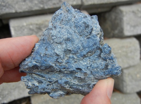
Locality 2 is on the next street down, Colgett Drive, which is too new to be shown on the base map above. It exposes serpentinite all the way to the end, where I collected this fragment to take home.

crestmont-blue-specimen

I wanted to inspect it as closely as I know how. I have several hand lenses as well as a teeny pocket microscope that gets me up to 45X. With those tools, I perceive that the rock consists of blue bits the color of glaucophane in a matrix of light-colored serpentine. I continue to think of it as blueschist, but I’ll save that discussion for a later post. The point is, just because this area is mapped as serpentinite doesn’t mean it’s 100 percent one thing or another. But for all practical purposes this area is serpentine rock.

Locality 3 is the spot on Crestmont Drive I showed in my very first post, back in 2007. It looks a lot better now. You could creep around the fence and give it a good examination.

crestmont-ur-exposure

There are a couple of interesting things going on here. First is that just around the corner on the left side, where Butters Drive intersects Crestmont, the rock abruptly changes to the Knoxville Formation (KJk), a nice brown mudstone. The geologic map puts a thrust fault there separating the two rocks.

Second is that on the righthand side you can see signs of the pavement being disrupted by some sort of ground movement. Cracking related to it extends across the road. That has taken place in the 7-1/2 years since I last came here. I went to inspect it more closely, but my attention was drawn instead to an unusual sight: a swarm of bees gathered on open ground.

crestmont-bees

I lingered long enough to take two shots, but after the first one I sensed dozens of bees zipping past both my ears, so I let the poor critters be. It was a raw day, and I hope they found a new space to set up housekeeping.